VashonMap.com
|
|
I
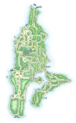
love interactive maps. And I love
old-fashioned, hand-drawn treasure maps.
When I moved to Vashon Island, WA, in the fall of 2003, I realized that
this charming community was a good candidate for me to try out an idea for a
homegrown, locally-illustrated, comprehensive map
directory for the web.

So in the spring of 2004, I put out a call to the local
artists to see if I could find someone to illustrate the map in an
affectionate, childrens'-story-book style. I found 22-year-old Annie Brule (click
here to go to her web site) who grew up on the island. For a $150 deposit, she drew three drawings
for me, so I could take the concept around to the merchant community and find
whether I could get them to sponsor the development of the site. I took Annie's drawings, scanned them, and
made a physical book that I could take around and show to the merchants of
downtown Vashon. The merchants were
overjoyed. A lot of them already knew
and loved Annie; that helped a lot. My
initial goal was to get 25 of the approximately 100 downtown merchants on
board. But 65 of them signed up!
With
just a marked-up set of Annie's drawings and some verbal explanation of our
plans, I raised $5000 from the merchants.
With these funds I paid Annie the rest of her fee, and
hired a programmer to turn it all into a web site.
It
was a delightful project, a sweet combination of art and technology, and the
whole island seemed to appreciate it. We
received lots of fan mail. The local
paper did a big front page feature on it. It became a popular site almost
immediately.
I
sold VashonMap.com to the Sallen Group, a local
rival, in 2007. VashonMap.com has since
been significantly altered. The hand-drawn maps are still on the site, but they
are no longer interactive.